Removal of the northern paleo-Teton Range along the Yellowstone hotspot track: New insights gained from uplift modeling, LiDAR, seismic reflection data, and lake coring studies
August 18TH (Thursday), 6 p.m., Via Zoom (online) & Live at Teton County Library. Open to Public
Presentation: “Removal of the northern paleo-Teton Range along the Yellowstone hotspot track: New insights gained from uplift modeling, LiDAR, seismic reflection data, and lake coring studies”
Presented by Dr. Ryan Thigpen, University of Kentucky
In the northern Basin and Range, the margins of the relatively low-relief Snake River Plain, which marks the track of the Yellowstone hotspot, are surrounded by multiple high-relief (>1.5 km) mountain ranges. These ranges, which are mostly composed of the uplifted footwalls of Basin and Range normal faults, are preserved both north and south of the denuded Snake River Plain. The simple geomorphic observation that mountain ranges do not exist along the track of the hotspot leads to the hypothesis that perhaps supercalderas completely “erase” or “remove” multiple mountain ranges, and by doing so, fundamentally reshape the topographic, fluvial, and climatic evolution of entire tectonic provinces.
In the early work addressing this hypothesis, our team used a technique known as thermochronology to constrain the timing and magnitude of cooling due to motion on the Teton fault and uplift of the Teton Range. This dataset was then integrated with fault modeling to demonstrate that the Teton fault, and by association, the Teton Range likely extended at least 40-50 km further north than the present-day topographic extent of the range, requiring that the topography be “removed” during migration of the Yellowstone caldera into its present position starting at ~2 Ma. In this talk, we will discuss insights gained over the last three years from: (1) 2-D uplift modeling of Teton fault evolution, (2) interpretation of LiDAR data along the fault system, including a recently available 2021 LiDAR dataset from Yellowstone National Park, (3) seismic reflection data acquired across modern fault scarps located between the Tetons and Yellowstone, and (4) new Jackson Lake seismic reflection data and long coring studies that bear on our understanding of modern Teton fault seismicity, including a potential first glimpse at the pre-Pinedale(?) earthquake history of the Teton fault.
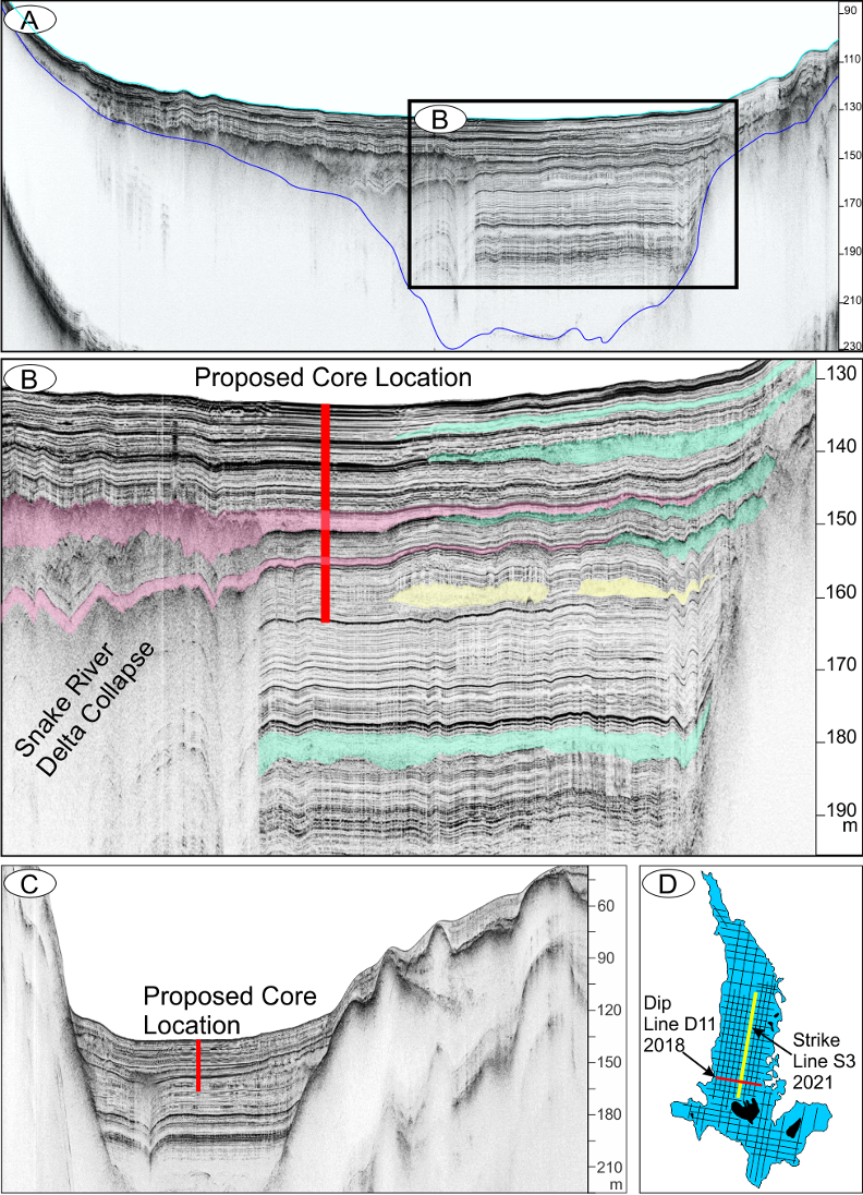
Univ. of Kentucky seismic lines with interpreted potential earthquake deposits or “seismites” that we hope to penetrate in the summer 2022 coring campaign.
Topic: Removal of the northern paleo-Teton Range along the Yellowstone hotspot track
Time: August 16th, 2022 06:00 PM Mountain Time (US and Canada)
Join Zoom Meeting
https://us02web.zoom.us/j/4555651818?pwd=U09ObDNZOEIyZmRtMEtsdUowQnJqdz09
Meeting ID: 455 565 1818
Passcode: 576063